Understanding Revit's Mysterious Survey Point
Revit has two coordinate system: Building coordinate system and Site coordinate system
The Project Base Point and Internal Origin of the project are part of the Building coordinate system. These points are usually placed in relation to the building. The best practice is place these origin points at the intersection of major grids. But that’s not what today’s post is about.
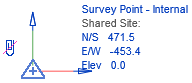
The Site Coordinate system has 2 points. You probably know about the Survey Point. But did you know there is also a secret Shared Site Origin? This point is always invisible. By default, your Survey Point is located at the same spot as the Shared Site Origin.
In the image below, we created a red marker the indicate the position of the Shared Site origin. You can see the Survey Point matches the origin, as indicated in the coordinates information of the point.

In the image below, we unclip and move the Survey Point. Notice there are now numerical values on the Survey Point information. These values represent the distance from the Survey Point to the Shared Site Origin.

What’s going on here? What is the effect of the clip? What purpose serves this Shared Site Origin? This post will attempt to answer all your questions and guide you to properly use the Survey Point.
MOVING THE SURVEY POINT: CLIPPED OR UNCLIPPED?
To clip or not to clip? That is the question.

When selecting the Survey Point, you will see a clip icon next to it.

When moving a clipped Survey Point, the Shared Site origin will also be moved. Notice that the values under Shared Site aren’t changed.
However, if you unclip the Survey Point before moving it, it will move independently from the Shared Site Origin. You know that the Survey Point doesn’t represent the Shared Site origin when the coordinates displayed are not equal to 0.
Generally speaking, this is not a good situation to be in. The Survey Point isn’t very helpful when it doesn’t represent the Shared Site origin. Let’s explore why.
Are you enjoying this post? Make sure to check out our popular BASICS learning package. It’s the most fun and effective way to learn Revit online.

SPOT COORDINATES AND SPOT ELEVATION ACTUALLY REFER TO SHARED SITE ORIGIN
When using the Spot Coordinate and Spot Elevation tools, you have 3 options to use as Coordinate Origin: Project Base Point, Survey Point and Relative (relative usually refers to the internal origin).

Autodesk are lying to you: the Survey Point option doesn’t actually refers to the Survey Point, but to the Shared Site Origin.
Every single instance where “Survey Point” can be used as a reference for something in Revit, it is actually referring to the Shared Site Origin. Another example would be the Levels origin. In the type properties you can select Survey Point as the Elevation Base. Again, that’s a lie. It is actually referring to the Shared Site Origin.
In the example below, we use a red lines to identify the position of the Shared Site Origin. You can see that the level height is referring to this point and not the Survey Point.

That means that an unclipped and moved Survey Point is completely useless and cannot be used as a reference for anything. I’ve received many emails telling me that it is good practice to unclip the Survey Point. That’s up to you, but be aware that you can create confusion when using the Spot Coordinates, Spot Elevation and Levels using the Survey Point as the coordinate origin.
USING THE SURVEY POINT TO POSITION THE GEODETIC MARKER
I’ve received some emails telling me that the correct way to use the Survey Point is as follow: position the shared site origin. Unclip the Survey Point and move it to a site position like a geodetic marker. There are no real benefits to doing something like this. The Survey Point doesn’t even print.

If you really need to graphically represent such a point, you should use a generic model family instead of the Survey Point icon.
DISTANCE FROM THE PROJECT TO THE SHARED SITE ORIGIN
Both the Project Base Point and the Survey Point will display their distance to the Shared Site Origin when they are selected. That means just the Project Base Point is enough to teach us about the site coordinates. An unclipped Survey Point doesn’t provide any value to your model. Another reason to leave it clipped.

POSITIONING THE SHARED SITE ORIGIN TO AN ELEMENT ON THE SITE
There are a few ways you can use the Shared Site Origin tool. Your project can be geo-referenced to a real world coordinate system (Lat, Long). In this case, that means the Shared Site Origin will be very far away from your project.
Not every project needs this kind of geo-referencing. Another way would be to position the shared site origin to an element on your site. Maybe to the intersection of property lines or to a geodetic marker.
That’s the technique we’ve showcased in the blog post called 12 Steps To Create A Shared Site In Revit. The Survey Point and Shared Site origin are both placed at the intersection of a property line. This point also matches the origin of the CAD survey file.

If you are using placing your Shared Site Origin in relation to a local element on your site, I would strongly urge you to keep the Survey Point clipped and pinned, perfectly matching the position of the Shared Site Origin.
GEO-REFERENCING IN A REVIT MODEL
There is a scenario where you might want to keep your Survey Point unclipped and away from the Shared Site Origin. That’s when you are geo-referencing your Revit Model using real-world coordinates, like the WGS84 system.
You cannot assign this kind of system just by using Revit. The only way to do it is by linking a Civil 3D or AutoCAD file and acquiring the coordinates. This feature has been available since Revit 2018.
In this example, we link a CAD file that contains WGS84 coordinates. Then, go to the Manage tab and use the Acquire Coordinates tool. Click on the linked CAD file.

When selecting the Survey Point, the Lat-Long information will be displayed in the instance properties. You can also see that the Survey Point didn’t even bother moving. When using Long-Lat coordinate system in Revit, the Survey Point doesn’t represent the shared site origin anymore.

The distance between the shared site origin and the Survey Point is so huge that it wouldn’t make much sense to keep them together. That’s the one case where it is acceptable to separate the Survey Point from the Shared Site Origin.
UNCLIP THE SURVEY POINT TO AVOID MOVING THE SHARED SITE ORIGIN BY MISTAKE?
Something I have heard quite often is that the Survey Point should be unclipped to avoid moving it mistake. Because moving a clipped Survey Point would also move the Shared Site, causing mayhem and confusion in your project.
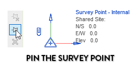
While that’s not a crazy idea at first glance, why not just Pin the Survey Point and make it invisible in all views? Or maybe just inform other users that the positon of the Shared Site Origin and Survey Point is final and that it should not be moved.
Just properly teach your colleagues and you shouldn’t have that kind of issue in the first place.
Regardless of the technique you choose to use, the position of the Survey Point and Shared Site Origin should be determined early in a project. Then, pin the points and don’t ever move them again.
The vast majority of projects probably don’t need to use the geo-referencing system.
WHAT IF THE ORIGIN IS 20 MILES AWAY FROM MY BUILDING?
Another frequent quip I hear from users is that it is bad practice to have views with super large extents, like 20 miles. In a case where the Shared Site Origin is 20 miles away from the building, some users think you should unclip and move the Survey Point to avoid weird issues.
It is true that there might be issues with larger views. But only when the actual geometry is super wide. If you have a 20 miles large building, yes, you might run into some issues.
The Survey Point isn’t considered as a geometric component. That means it won’t cause any bug if it is 20 miles away from your building in a view.
That means the 20 miles bug is not a good reason to unclip and move the Survey Point.
You can read more about issues when using geometry with large extents here: https://knowledge.autodesk.com/support/revit-products/troubleshooting/caas/CloudHelp/cloudhelp/2019/ENU/Revit-Troubleshooting/files/GUID-D30C39FF-3A53-47DE-8E9E-11B2AB808A07-htm.html
RECAP:
1- Don’t unclip and move your Survey Point.
2- Only exception to point #1 is if you are geo-referencing your Revit model with lat-long coordinates. In that case, the shared site origin would be too far away.
3- The Spot Coordinates, Spot Elevation and Levels tools set to “Survey Point” don’t actually reference the Survey Point, they refer to the Shared Site Origin.
4- Set the Shared Site Origin and Survey Point early on in the project. Pin them, don’t ever move them again.
We have a crazy amount of content about Revit’s coordinate system. Why don’t you download our free pamphlet PDF about shared sites?
This article was originally published on RevitPure and has been republished here with permission.

cover image © pixabay